
What is Griffiths Valuation ?
Griffith’s Valuation,is one of Ireland’s premier genealogical resources, referencing approximately one million individuals who occupied property in Ireland between 1848 and 1864. Griffith’s Valuation, or Primary Valuation of Ireland, was executed under the direction of Sir Richard Griffith to provide a basis for determining taxes. This involved establishing the value of all privately held lands and buildings in both rural and urban areas in order to figure a rental rate for each unit of property. The resulting survey was arranged by barony and civil parish, with an index to townlands appearing in each volume. The original volumes of the survey are held in the National Archives, Dublin, and Public Record Office, Belfast.Griffith’s Valuation is an invaluable reference for family historians with ancestors in Ireland in part because no census material from the nineteenth century has survived. In effect, because it is the only detailed guide to where in Ireland people lived in the mid-nineteenth century and what property they owned or leased, Griffith’s Valuation serves as a census substitute for the years before, during, and after the Great Famine. Griffith’s Valuation is also a valuable record of social and economic data and includes map reference numbers that can help researchers identify and perhaps locate property on Ordinance Survey maps created before the valuations took place.Few other records can be used to identify an Irish ancestor’s exact place of origin, and only Griffith’s Valuation links an individual to a specific townland and civil parish. This is extremely important, since the first step in Irish genealogical research is to identify an ancestor’s townland and civil parish, which can lead you to ecclesiastical parish records of births and marriages.
Records in this database are indexed by:
- Name of occupier
- Name of leaser
- County of residence
- Barony of residence
- Parish of residence
- Townland of residence
- In addition, pages from the Valuation may include street, subdivision, and ordinance survey page numbers, as well as a description of property, acreage, and valuation.
-
County Date of completion of survey Carlow 28 June 1853 Cork 20 July 1853 Dublin 9 July 1853 Kerry 19 July 1853 Kilkenny 8 July 1853 Kilkenny City 8 July 1853 Limerick 29 June 1853 Limerick City 29 June 1853 Queen’s County 28 June 1853 Tipperary 29 June 1853 Waterford 5 July 1853 Waterford Borough 5 July 1853 Dublin City 31 Oct 1854 Kildare 18 July 1854 Wexford 7 July 1854 Wicklow 4 July 1854 King’s County 2 July 1855 Longford 6 July 1855 Louth 5 July 1855 Drogheda Borough 6 July 1855 Meath 10 July 1855 Westmeath 5 July 1855 Clare 3 July 1856 Galway Town 14 July 1856 Cavan 25 June 1857 Galway 29 June 1857 Leitrim 6 July 1857 Mayo 13 July 1857 Donegal 6 July 1858 Roscommon 1 July 1858 Sligo 7 July 1858 Londonderry 16 July 1859 Tyrone 13 July 1860 Monaghan 1 July 1861 Antrim 10 July 1862 Carrickfergus 10 July 1862 Fermanagh 4 July 1864 Down 12 July 1864 Armagh 1 June 1865
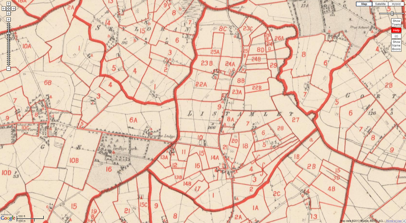
- Tyrone’s started in 1851, and this is was how Listamlet was then in 1860
Griffiths valuation can be accessed through askaboutIreland ,and the Family’s living in 1860 Listamlet ,can be found here ,there are three pages to be seen,
- understanding the valuation
- Map of Listamlet 1860
- occupiers of houses in Listamlet 1860 ,three pages can be found here

Pingback: Griffiths valuation | Listamlet ,Listamlaght
hi! hope you are well, I am afraid the maps on askaboutireland dont seem to open for me, do you know do they still work?
thanks.
LikeLiked by 1 person
Hi there Conor, so sorry I missed your comment, askaboutIreland seems to be working ok , does the problem still happen at your end?
LikeLike
Yes I’m afraid it does.
Thanks for your concern.
It now tries to bring up a map but there’s no image just the map controls.
Hope you have a good weekend.
LikeLike